- Mongabay is publishing a new edition of the book, “A Perfect Storm in the Amazon,” in short installments and in three languages: Spanish, English and Portuguese.
- In this section, Killeen looks at industrialized crops in Brazil, specifically in Mato Grosso, where irrigation is expected to be heavily impacted by decreasing rainfall as a result of climate change and deforestation.
- The outlook over the next few years is grim. While current extraction levels are within parameters, the effective expansion rate of 10% per year will eventually outstrip surface water supplies, increasing demand for groundwater.
- According to studies conducted in Mato Grosso, the combined surface and groundwater resources could support 3.9 million hectares of agriculture.
The agro-industrial farms of Mato Grosso are among the most efficient on the planet; they benefit from abundant rainfall and a long rainy season, which allows them to plant and harvest two crops per year. They do not operate without risk, however. Both crop cycles fail during periodic droughts (1985, 1991, 1993, 2009, 2016), and the second harvest is often constrained by limited soil moisture at the end of the rainy season. The recent decline in mean annual precipitation, the consequence of climate change and deforestation, manifests largely in a delay in the onset of the rainy season. Farmers must wait until it rains to seed their crops, a delay that reverberates through the subsequent first harvest (typically soy) and the sowing of the second crop (typically maize) and its eventual harvest, which is known as the safrinha.
The gradual (non-tipping point) decline in precipitation has increased the probability of poor maize yield. Some producers are using center-pivot irrigation systems to manage the risk of dryland farming; the number has grown from fifty in 2000 to more than a thousand in 2021. The original motivation may be to alleviate drought stress during the safrinha (May, June, July), but precision water management can increase yields during both crop cycles by ensuring optimum soil moisture during key stages of plant development (seedling, flowering and grain filling). Once the investment is made, producers use the equipment throughout the year. Some are planting a third crop.

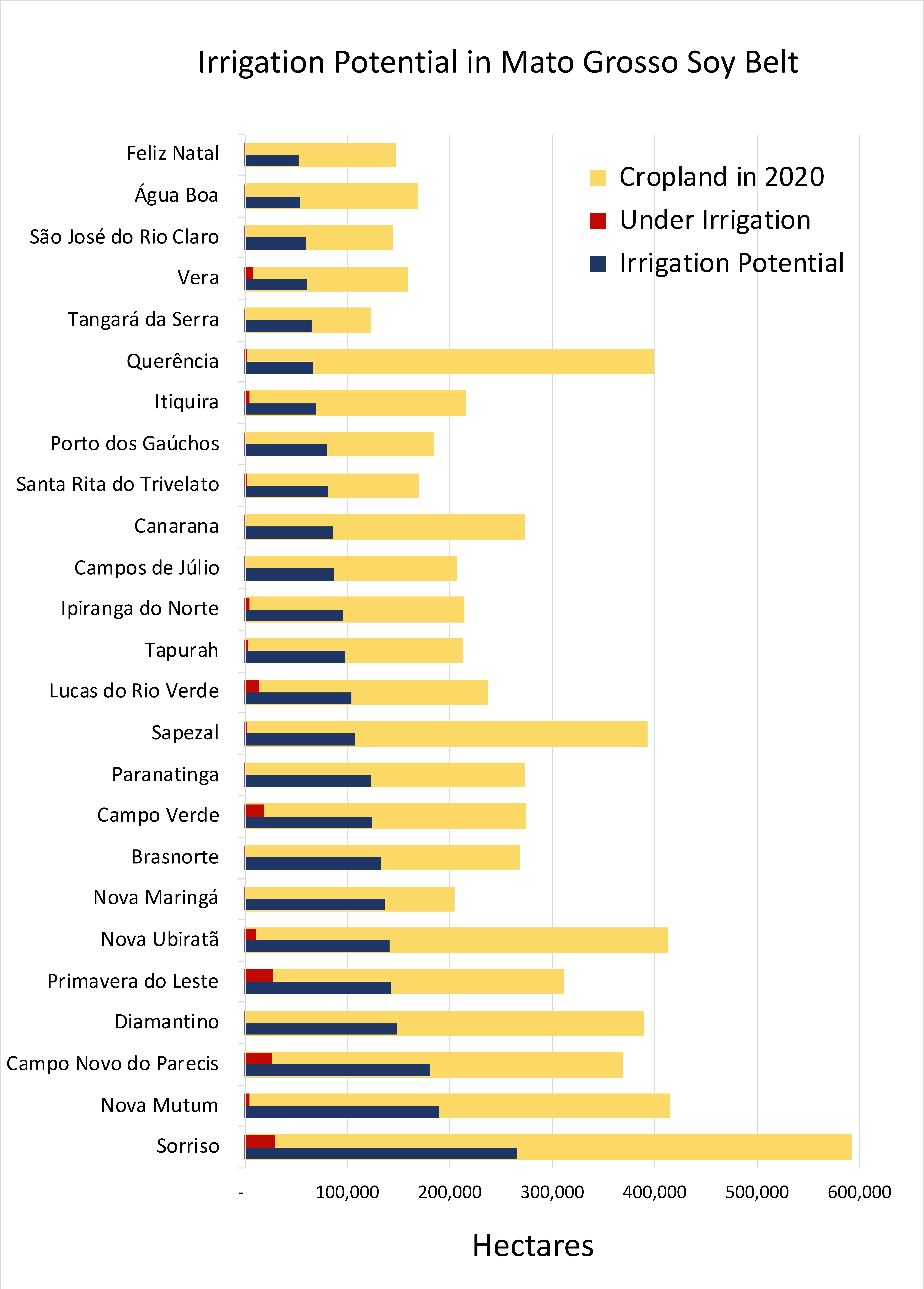
Irrigation circles were observed on approximately 2% (125,000 hectares or 308,000 acres) of the area under intensive cultivation in 2020 (10 million hectares or 24.7 million acres). Most producers are pumping water directly from rivers or from small impoundments on upstream watercourses. Expansion has been most notable on the headwaters of the Teles Pires (Tapajós) and Río das Mortes (Araguaia), followed by the Juruena (Tapajós) and Alto Xingu.
Irrigation systems are regulated by the state environmental authority Secretaria de Estado de Meio Ambiente do Mato Grosso (SEMA) in coordination with a state water council (Conselho Estadual de Recursos Hídricos de Mato Grosso – CEHIDRO) and basin-specific governance committees. Current guidelines stipulate that surface water removals should be limited to 70% of minimum waterflows (Q95) and no individual stakeholder can take more twenty per cent of that total. Current levels of take-off are well within those guidelines, but the ongoing rate of expansion (ten per cent annually) will eventually outstrip surface water supplies. Long before that happens, producers will start exploiting the groundwater resources of the Parecis Aquifer, a massive reservoir in the sandstone rock formations that overlay the Amazon Craton .
Information on both surface and groundwater resources was used by the national water agency (Agência Nacional de Águas e Saneamento Básico – ANA) when preparing the Atlas Irrigação, a national planning document that has mapped the nation’s irrigation potential. According to that document, Mato Grosso has the water resources necessary to irrigate 3.9 million hectares of cropland, an area equivalent to ~40% of the total area under cultivation in 2020. Of that total, about 500,000 hectares would depend upon groundwater resources, while the remainder would be extracted from the region’s rivers.
Ironically, irrigation at that scale would partially compensate for the decline in rainfall caused by deforestation because it would enhance evapotranspiration and convection over agrarian landscapes. Simultaneously, however, industrial-scale irrigation would disrupt the seasonal waterflows that support the biodiversity and ecosystem function on the upper Tapajós, Xingu and Araguaia watersheds. Climate change and deforestation have already caused a significant decline in precipitation over the Southern Amazon; nonetheless, waterflows in those rivers have maintained historical levels because of an increase in runoff from deforested landscapes. As irrigation systems multiply, these waterflow subsidies will disappear and, if the Southern Amazon passes a deforestation-induced climatological tipping point, the impacts on downstream ecosystems and communities will be catastrophic.
If (when) that occurs, agribusiness will scramble to install irrigation systems. If history is any guide, they will use all the available surface water and overexploit the Parecis Aquifer – unless regulatory authorities act pre-emptively to limit irrigation. That may be difficult, however, because the current 35-year span of the current permit system is based on historical climate data that overestimates future water resource availability. The current regulatory framework has been questioned by hydrologists, who contend surface water abstractions should be limited to twenty per cent of the total water volume during any specific temporal period. Removals from the aquifer are more complicated to measure and regulate because they are based on balancing the recharge rate with the rate of extraction. The recharge rate in the future is unknown.

As surface water abstractions in the Tapajós basin increase, they will threaten the economic viability of four hydropower facilities. Simultaneously, the riparian habitats and Munduruku communities on the middle Tapajós will suffer from reduced water flows, particularly if dam operators mitigate reduced waterflows by retaining a greater share of water. On the Xingu, the river corridor is protected by the Parque Indígena do Xingu (PIX), home to sixteen different ethnic tribes, but the headwaters are located entirely on private land. The much-debated provisions of the Mato Grosso ZEE could potentially limit the expansion of center-pivot systems, because it expressly identifies landscapes that are important for the management of the water resources of the Amazon.
As of October 2021, there was no evidence that green bonds were financing irrigation agriculture in the Brazilian Amazon. This situation will change in the near future because irrigation projects are eligible under ESG standards and figure prominently in discussions about climate change adaptation. Solar energy powers irrigation systems at multiple locations in Mato Grosso, and the ongoing expansion of the maize-based biofuel industry is being finance by green bonds. Assertions that these operations are compliant with ESG criteria must, eventually, be reconciled with their long-term impact on water flows on aquatic ecosystems of the Tapajós, Xingu and Araguaia rivers and the livelihoods of indigenous communities on those rivers.

Other crops for which irrigation technology is employed at scale are rice in Tocantins (100,000 hectares or 247,100 acres), coffee in Rondônia (43,000 hectares or 106,255 acres) and oil palm in Pará (25,000 hectares or 61,776 acres). Irrigation technology has been installed in an unknown area, perhaps as large as 10,000 hectares, as part of a new business model to cultivate açaí in plantations (see below). Center-pivot irrigation systems have been introduced on the alluvial plain of Santa Cruz but they have not been widely embraced, despite the considerable drought risk that characterizes that region.
“A Perfect Storm in the Amazon” is a book by Timothy Killeen and contains the author’s viewpoints and analysis. The second edition was published by The White Horse in 2021, under the terms of a Creative Commons license (CC BY 4.0 license).
Read the other excerpted portions of chapter 4 here:

Chapter 4. Land: The ultimate commodity
- Land in the Pan Amazon, the ultimate commodity: Chapter 4 of “A Perfect Storm in the Amazon” January 9, 2024
- Obtaining a certified legal title in the Pan Amazon January 11, 2024
- The dynamics of violence in pursuit of land in the Pan Amazon January 17, 2024
- Agrarian reform agencies and national land registry systems in the Pan Amazon January 18, 2024
- INCRA as a regulatory agency January 25th, 2024
- Terra Legal program to regularize small property owners January 25th, 2024
- How Bolivia pioneered agrarian reform in South America February 1st, 2024
- A coalition created by a demand for land is splintered by a competition for territory February 1st, 2024
- How to achieve the regularization of rural land in private properties in Peru? February 6th, 2024
- A particular agrarian reform process in Peru February 8th, 2024
- The creation of settlements in the Ecuadorian Amazon February 13th, 2024
- Land distribution in Colombia, Venezuela and Guyana February 14th, 2024
- Land use planning helps advance conservation in Brazil February 21th, 2024
- Low implementation of land use maps in Andean countries affects conservation outcomes and agricultural productivity February 22th, 2024
- Ecuador, Colombia and the Guiana Shield join the planning of sustainable land use February 28th, 2024
- In the Amazon, what happens to undesignated public lands? February 29th, 2024
- What is most convenient in land distribution? March 5th, 2024
- Land irrigation as an obstacle to agricultural intensification in Mato Grosso March 6th, 2024
To read earlier chapters of the book, find Chapter One here, Chapter Two here, and Three is here.


